Mt. Chamberlin is the highest mountain in the Brooks Range of Alaska and we skied it in July 2010, packrafting the Hula Hula River to Kaktovik after the ski mission. In between, we witnessed the migration of the porcupine herd of caribou – amazing!
Is it really a year later and I’m just now writing about this? I guess so, but such is life . . . I guess that means it’s been a good year full of interesting things to distract me 🙂 The group consisted of Bobby and me in his plane and Matt Harper and Nellie Love in Matt’s plane – the two had been introduced before this trip, then spent some plane and mountain time in the Brooks on the trip, which turned into a romance and now engagement . . . so yeah, a lot can happen in a year!
Suffice it to say this was one of the coolest trips of all time – we flew into Schrader Lake with Bobby’s Supercub and Matt’s 185, with the hopes of climbing and skiing Mt. Chamberlin. From there, we’d do a plane shuttle to take Bobby’s plane to Kaktovik and then he/I would float the Hulahula to the coast and Matt/Nellie could make it back for work as they had less time off . . .
Given the remoteness of the area and the infrequency with which the Brooks Range is visited, it was super difficult to get info on the “strip” we landed at, as well as intel on the area in general. The year before, Joe Stock and Matt Hage had skied Chamberlin for its first descent (although there was a claim made after their write-up that it had in fact been skied before – who knows!), landing on the Hulahula river and hiking in from the opposite side. I think they’d wanted to land on the Shrader Lake side, but the strip was too wet for the larger plane – thankfully we had the cub to check it out with, and do shuttles from a bigger landing strip if necessary . . .
Mt. Chamberlin from the air – we went up the far looker’s left

As it turned out, we were able to get both planes down with no problem – we had perfect weather too, simply stunning country!

We had a lovely evening by the lake and a nice dinner, getting up the next morning at a pretty mellow hour, knowing that with 24 hrs of daylight, we’d have whatever time we needed . . .
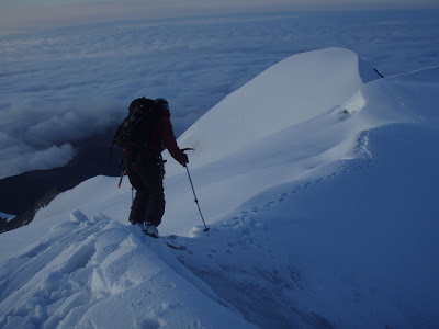
Hiking up, Shrader Lake below

Matt and Nellie

Gaining some elevation as we neared the glacier toe . . .

When we got to the glacier, Matt and Nellie decided this was more ski mountaineering than they were up for, and opted to descend and explore the area near camp. Bobby and I continued up to see what the peak had in store . . .
We started out with about 1000′ of cramponing up bare glacier – to the right of my head is the main face – we started up the gut, but got shot down by slab avalanche conditions near the ridge, which forced us to descend and ultimately climb on the far climber’s left.

So, we headed up the gut of the face, finding nice climbing conditions – the route looked super straightforward from below, but as it turned out, this mountain just did not give it up!!! Our first obstacle was a super gaping crevasse – I probed it and got air pretty much right away, so we decided to look for a better crossing. We descended to the climber’s right and found a nice snowbridge, which I was able to safely get across and then place a screw to belay Bobby across. He got safely across, and then climbed above until the end of the rope, which happened to also be when he got into some nasty snow – about a 4″ thick crust on facets – classic slab avalanche conditions – uggh. So, we again descended, first trying the far climber’s right, but realizing that we’d be over death exposure and it wasn’t worth it. So, we essentially decided to go down . . . but, as I was traversing back over to our route, I noticed a nice ice line (read: no avy danger) on the far climber’s right, so traversed over to it. Amazingly, the route went, so we were upward-bound once again – hooray!!! We gained the ridge fairly quickly and then climbed up the last face, happy that the slab we’d experienced below was not present up higher. We had one scare near the summit as I found a huge crevasse right near the summit that I was definitely not expecting, but we navegated around it and topped out about 10pm.
Climbing up the gut, just before the first crevasse . . .

Me on the final steps to the summit!

I have to say that this summit was one of the most special moments of my life. Being at the highest point in the Brooks Range in the full light of 10pm, with a sea of clouds below was almost surreal. That we’d suspended doubts and safely navegated the face, working well together throughout, was super fulfilling from a relationship standpoint. That the clouds had hung in the valley and let us continue climbing was wonderful . . . truly an incredible experience.
Enjoying the summit – hooray!!!
And then it was time to ski! Of course, on a big mountain with lots of object hazard, it wasn’t like we had it in the bag by any means, but it does always feel good to get to the skiing part of a ski mountaineering trip . . . the climbing part is cool and all, but . . .
All things considered, the line skied pretty well – we pretty much followed our up route, enjoying some glacier ice intermixed in some of our turns, but edgeable all the way down. We had a nasty breakable crust near the bottom of the face, but it was more annoying than dangerous, so we just suffered through it. Props to Bobby since he was a telemarker until a few months before, so he really didn’t have that many days on dynafits before this trip!
Me skiing off the top – hooray!

Our line below me . . .


When we got off the face, we still had all that bare glacier to navegate . . . being a skier, and a lazy person, I had no desire to crampon back down, so suggested we keep the skis on . . . it wasn’t that steep after all and it was smooth enough to navegate . . . and so we did 🙂 I’m not gonna lie, it wasn’t all pleasant, but it did have that feeling of ridiculousness that made us roll our eyes and laugh, glad that we could do it!
Loving the glacier ice!

Bobby on the extreme lower half, our line illuminated in the background
 15 hours after leaving camp, we safely arrived back to the tent, stoked on a successful climb and ski, and glad to be off our feet! The next morning, I was pretty out when Bobby woke me up abruptly . . . I thought something was wrong, but instead it was that our camp was completely surrounded by caribou!!! By some miracle, we were in the middle of the migration of the Porcupine herd of Brooks Range caribou – it was incredible!!! We got up and watched in camp as we ate breakfast, deciding afterward to head up-river a bit to perch on a rock and watch them up-valley as well. As we were joking about wanting to see some drama, a wolf appeared a few hundred yards in front of us and started hunting . . . it was insane to watch the caribou behaviour, how he chased them into sheep country (I had no idea caribou were so nimble!), and ultimately their ability to outwit the wolf – we watched for about 2 hours and the wolf was unsuccessful – seems kind of crazy in a herd that big that he couldn’t get one – pretty cool to watch, and awesome to armchair quarterback the hunt from our rock perch!
Can you say caribou?!?
After about 5 hours of watching caribou pass, with no end in sight, we decided to move on with the plane shuttle . . . so the boys did some flying while Nellie and I did some hiking . . .
Grasser strip on the upper Hulahula

Nellie and me on our hike

A heck of a place to chill for the night . . . upper Hulahula

The next day, Matt and Nellie took off, and Bobby and I spent most of the day walking upriver to check out the higher elevations before starting our float out . . . just as we got in the rafts, the rains came – uggh! Thank goodness for drysuits!!!
Day 2 of the float was about the coldest I remember being – I made Bobby promise me we could go to Chena Hot Springs when we got to Fairbanks, feeling like the only way I could handle the cold is if I knew there would eventually be an end in sight!! Given all the rain, we had the river at flood stage, which made the canyon section pretty festive!!! The wave trains were super big – when Bobby went before me, he would disappear in the troughs 🙂 The cool thing was that it was just big waves, but no holes or other scary river features, so it was a fun section. Just after the canyon, as we reached the last mountain before the North Slope, we decided to stop and camp with the hopes that the weather would be nice enough to get a hike in the next day before we had to leave the beautiful country . . .
Before the canyon – pretty mellow floating, but the river was cranking so we made good time . . . too bad we couldn’t enjoy the views though!!

Trying out new styles in the Brooks Range

The next day was clear enough to get a hike in, so up we went . . .

Looking north . . . super cool country

Floating out of the Brooks – our hike is just on the left side of the photo – thankfully the river stayed decently fast for awhile . . .
 The next day, we floated all the way to Arey Island in the Arctic Ocean – after a night of rain, we had a sunny morning (hooray!) and the river was still moving pretty well for the first part of the day. As we neared the coast, the gradient lessened substantially and we had a helluva crosswind that made it necessary to paddle 100% of the time or get swept out of the main current and into a gravel bar. I did not stay a happy camper in this section, wondering why on earth I would ever voluntarily go to the north slope . . . but eventually we made it and got to the bug-free island at around 1am . . .
Bobby in camp

Off ice in the river . . . I guess this is the arctic after all!
 The next morning, I woke up super sick, but was eventually able to get moving and paddle the 4 miles into Kaktovik – it was a nice flatwater paddle in no wind, right along the pack ice – pretty cool actually. We arrived to find the plane there and waiting for us, got adopted by a native man the drove us around town behind his 4-wheeler and took us to the general store, and generally enjoyed Kaktovic on the rare sunny day we had been blessed with! From there, it was a flight through Kavik camp to gas up, then to Anaktuvuk for a bathroom break, and on to Bettles for the night before flying back to Anchorage via Fairbanks . . . definitely a long flight!!!!


 I guess it’s really hard to capture a trip like this in a blog post, but I guess that’s the beauty about things like these 🙂


 15 hours after leaving camp, we safely arrived back to the tent, stoked on a successful climb and ski, and glad to be off our feet! The next morning, I was pretty out when Bobby woke me up abruptly . . . I thought something was wrong, but instead it was that our camp was completely surrounded by caribou!!! By some miracle, we were in the middle of the migration of the Porcupine herd of Brooks Range caribou – it was incredible!!! We got up and watched in camp as we ate breakfast, deciding afterward to head up-river a bit to perch on a rock and watch them up-valley as well. As we were joking about wanting to see some drama, a wolf appeared a few hundred yards in front of us and started hunting . . . it was insane to watch the caribou behaviour, how he chased them into sheep country (I had no idea caribou were so nimble!), and ultimately their ability to outwit the wolf – we watched for about 2 hours and the wolf was unsuccessful – seems kind of crazy in a herd that big that he couldn’t get one – pretty cool to watch, and awesome to armchair quarterback the hunt from our rock perch!


 The next day, we floated all the way to Arey Island in the Arctic Ocean – after a night of rain, we had a sunny morning (hooray!) and the river was still moving pretty well for the first part of the day. As we neared the coast, the gradient lessened substantially and we had a helluva crosswind that made it necessary to paddle 100% of the time or get swept out of the main current and into a gravel bar. I did not stay a happy camper in this section, wondering why on earth I would ever voluntarily go to the north slope . . . but eventually we made it and got to the bug-free island at around 1am . . .
 The next morning, I woke up super sick, but was eventually able to get moving and paddle the 4 miles into Kaktovik – it was a nice flatwater paddle in no wind, right along the pack ice – pretty cool actually. We arrived to find the plane there and waiting for us, got adopted by a native man the drove us around town behind his 4-wheeler and took us to the general store, and generally enjoyed Kaktovic on the rare sunny day we had been blessed with! From there, it was a flight through Kavik camp to gas up, then to Anaktuvuk for a bathroom break, and on to Bettles for the night before flying back to Anchorage via Fairbanks . . . definitely a long flight!!!!


amazing trip
Did you use sprayskirts on your pack rafts for this trip? And about how many days on the water? Anything you wish you had that you didn’t bring? And things you brought that you would have left behind? I’m planning a jaunt myself to this area next month. Thank you for the information.
DEFINITELY yes to spray skirts – we had drysuits too and I still remember this being one of the coldest floats ever on the upper river. I think we had 2 full days on the water plus a morning paddle from Arey Island to Kakotovik . . . you could definitely spend more though if you hike along the route. I pretty much have a standard kit I use and it’s pretty optimized, so probably wouldn’t change anything re: my packing.
Yes dry suits a must. Thank you. Do you recall where you put in for the float after Chamberlain success?
grasser strip